Polish Lakes, Sea and Mountains
The landscape of Poland can be divided broadly into three relief groups: the lowlands, the highlands, and the mountains. There are sharply contrast between the northern two-thirds of the country and the southern one-third. The northern zone's principal topographical characteristic is the North European Plain |
![]() |
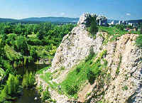
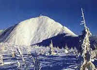
The southern one-third of Poland consists of various upland areas and adjacent or intervening lowlands. Along the southern border are the Carpathian and Sudeten mountains. The highest elevation is Rysy (2,499 m) in the High Tatra range of the Carpathians. The eastern extremes of Poland display characteristics common to eastern Europe, but the rest of the country is linked to western Europe by structure, climate, and the character of its vegetation. |
The Coastal Plain |
|
The Baltic Coastal Plain stretches across northern Poland from Germany to Russia (Kaliningrad region). It is largely occupied by the ancient province of Pomerania. The Pomeranian (Pomorska) Bay in the west and the Gulf of Gdansk in the east are the two major inlets.
|
The lake region | |
![]() |
The belt immediately to the south of the coastal plain presents, with its many lakes, a varied, hilly landscape. Wide river valleys divide the region into three parts: the Pomeranian (Pomorskie) Lakeland; the Masurian (Mazurskie) Lakeland, east of the lower Vistula; and the Great Poland (Wielkopolskie) Lakeland. There are some 9,300 Polish lakes with areas of more than 1 hectare (2 1/2 acres), and their total area is 1 percent of the national territory. The larger settlements and the main communications routes of this zone lie in and along the river valleys; the remainder of the area is mostly wooded and thinly populated. |
The Central Lowlands |
The character of the central lowlands is
generally flat and monotonous. The basins of the main rivers divide the
area into the Silesian Lowland, which lies in the upper Oder; the
southern Great Poland Lowland, which lies in the middle Warta basin; and
the Mazovian and Podlasian lowlands, which lie in the middle Vistula
basin. Lower Silesia (main city: Wroclaw) and Great Poland (Poznan) are
important agricultural areas, but large industrial centres are found in
many parts of the central lowlands. Warsaw, the capital, situated on the
middle Vistula, is most prominent.
|
The Little Poland Uplands | |
|
The uplands of Little Poland (main city: Cracow), south of the central lowlands, extend from east to west, but they are folded transversely. In the west is the Silesian-Crakow upthrust, with rich deposits of coal. A second upthrust is formed by the ancient rocks of the Swietokrzyskie ("Holy Cross") Mountains, which reach a maximum elevation of 612 m. East of the Swietokrzyskie Mountains, and the valley of the Vistula, beyond which lie the Lublin (Lubelska) Uplands. In the south occur patches of loess on which fertile brown- and black-earth soils have developed. |
The Sudeten | |
The Sudeten and its foreland are part of the larger Bohemian Massif. Their highest portion, the Karkonosze, reaches 1602 m (Sniezka) above sea level. The region has many small towns. Resorts and spas are found in more secluded areas |
![]() |
The Carpathian Mountains |
|
![]() |
The southernmost portion of Poland embraces the Carpathian Mountains and their associated chains and basins. The sub-Carpathian basins contain deposits of salt, sulfur, and natural gas and some petroleum.There are both a large rural population and many towns of medium size. The highest peak of the Tatras -with peak Rysy of 2,499 metres, are the highest portion of the Polish Carpathians. Zakopane, the largesttourist and resort centre in Poland, lies at their feet. |